.webp)
.webp)
Kyrgyzstan Solo Adventurers Guide to Thru Hiking Pamir Alay Trail
Introduction to the Pamir-Alay Trail
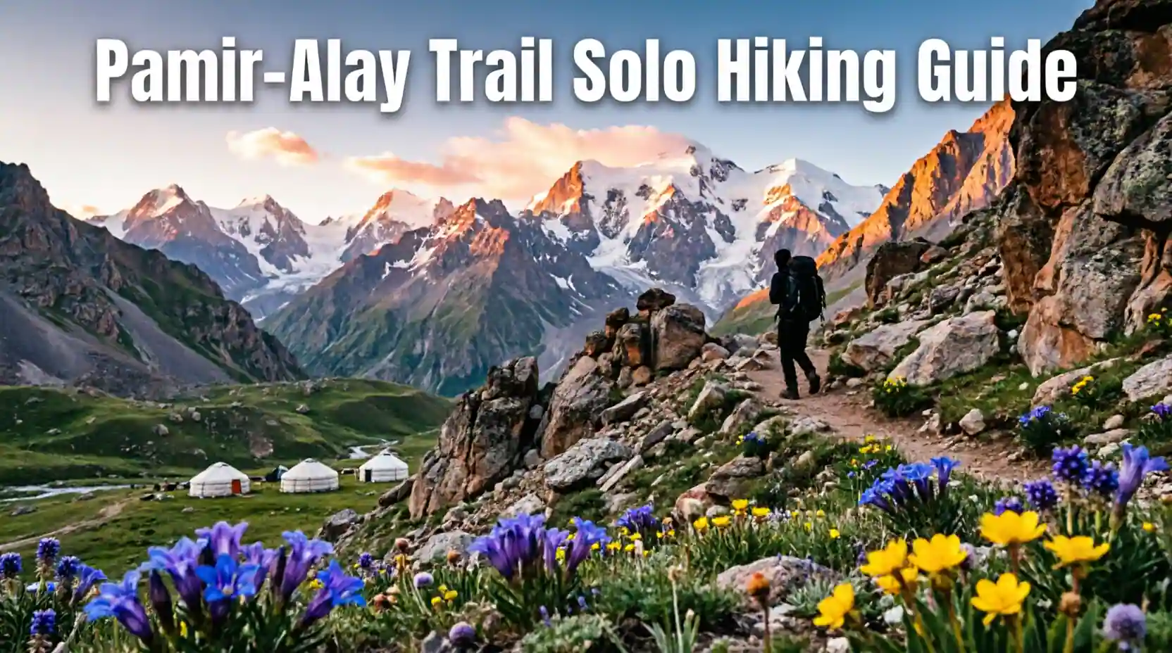
The Pamir-Alay Trail represents one of Central Asia's most spectacular and challenging long-distance trekking routes.
Stretching approximately 350 kilometers through Kyrgyzstan's dramatic mountain landscapes, this trail traverses the mighty Pamir-Alay mountain range.
Solo adventurers find unparalleled opportunities for wilderness immersion, cultural encounters, and physical challenge on this remote route.
The trail connects remote valleys, high mountain passes exceeding 4000 meters, and traditional Kyrgyz communities.
This comprehensive guide prepares solo hikers for every aspect of thru-hiking this remarkable Central Asian trail.
Trail Overview and Route Description

The Pamir-Alay Trail winds through some of Kyrgyzstan's most pristine and rugged mountain terrain.
The route typically takes 18-25 days to complete depending on pace, weather, and side excursions.
Starting points vary but most thru-hikers begin near Osh or in the Alay Valley region.
The trail traverses multiple high passes, glacial valleys, and remote plateaus with minimal infrastructure.
Understanding the route's character and challenges is essential for proper preparation and safety.
Trail Sections and Key Segments
Section 1: Alay Valley approach through traditional Kyrgyz villages and pastoral landscapes.
Section 2: Ascent to high passes exceeding 4000 meters with panoramic mountain views.
Section 3: Remote plateau crossing with minimal human presence and maximum wilderness experience.
Section 4: Descent through glacial valleys with opportunities for glacier viewing and photography.
Section 5: Final approach to trail terminus with cultural sites and resupply opportunities.
Elevation Profile and Difficulty
Trail elevation ranges from 2800 meters at lowest points to over 4300 meters at highest passes.
Multiple high altitude passes require acclimatization and physical fitness for safe crossing.
Total elevation gain exceeds 15000 meters over the complete route.
Technical difficulty is moderate with no climbing equipment required though route finding skills essential.
Weather exposure and remoteness increase objective hazards requiring self-sufficiency and preparedness.
Best Time to Hike the Pamir-Alay Trail

Seasonal timing critically impacts trail conditions, weather, and overall hiking experience.
The short hiking season runs from mid-June through September due to high altitude and continental climate.
Each period within the season offers distinct advantages and challenges for thru-hikers.
Understanding seasonal patterns helps optimize timing for individual preferences and risk tolerance.
Weather variability requires flexibility and contingency planning regardless of chosen timeframe.
Peak Season July to August
July and August offer warmest temperatures and most stable weather conditions.
Daytime temperatures at lower elevations range 15-25 degrees Celsius though nights drop below freezing at altitude.
All high passes typically snow-free though afternoon thunderstorms common.
Peak season means more fellow hikers and shepherds in alpine meadows.
River crossings easier as snowmelt decreases though still require caution.
Shoulder Season Considerations
Late June offers wildflower blooms and fewer hikers though some high passes may retain snow.
September provides stable weather and autumn colors though nights become very cold.
Early season June risks snow on high passes and swollen rivers from snowmelt.
Late season September risks early snowstorms and rapidly shortening daylight hours.
Shoulder seasons require additional preparation and flexibility with itinerary.
Permits and Regulations

Kyrgyzstan maintains relatively relaxed regulations for foreign hikers compared to many countries.
Understanding permit requirements and registration procedures prevents legal complications.
Border zone areas may require special permits depending on exact route taken.
Registration requirements exist though enforcement varies by region and current policies.
Proper documentation demonstrates respect for local laws and facilitates positive interactions.
General Trekking Permits
No general trekking permit required for most of Pamir-Alay Trail route.
Free movement allowed for foreign tourists throughout most of Kyrgyzstan.
Registration with local authorities required if staying in one location over 5 days.
Hotels and guesthouses handle registration automatically for guests.
Campers should register at nearest police station if staying in one area multiple days.
Border Zone Permits
Certain sections near Tajikistan border may require special border zone permit.
Permit obtained in Osh or through registered tour operators.
Processing time 3-5 business days requiring advance planning.
Cost approximately 500-1000 som depending on processing speed.
Carry multiple copies of permit and passport for checkpoint verification.
Physical Preparation and Training

Thru-hiking the Pamir-Alay Trail demands excellent physical conditioning and mental resilience.
The combination of high altitude, heavy pack weight, and consecutive long days creates significant physical stress.
Proper preparation prevents injury, enhances enjoyment, and increases likelihood of successful completion.
Training should begin at least 3-6 months before intended departure date.
Gradual progression builds fitness while minimizing overuse injury risk.
Cardiovascular Training
Build aerobic base through running, cycling, or hiking 4-5 times weekly.
Progress to long sessions of 3-5 hours simulating trail demands.
Include hill repeats and stair climbing to build leg strength and endurance.
Target heart rate zones appropriate for sustained all-day effort.
Final training months should include back-to-back long days with pack weight.
Strength and Conditioning
Leg strength critical for carrying heavy pack over mountainous terrain.
Squats, lunges, and step-ups build necessary lower body strength.
Core strength prevents back injury and improves pack carrying efficiency.
Upper body strength assists with trekking pole use and scrambling sections.
Flexibility work prevents injury and aids recovery between long hiking days.
Altitude Acclimatization
If possible arrive in Kyrgyzstan 1-2 weeks before trail start for acclimatization.
Spend several days at intermediate elevations 2500-3000 meters before starting.
Gradual ascent profile built into itinerary aids acclimatization.
Recognize symptoms of altitude sickness and be prepared to descend if necessary.
Hydration and avoiding alcohol during acclimatization period improves adaptation.
Essential Gear and Packing List

Proper gear selection balances weight, functionality, and reliability for multi-week wilderness trek.
Every item should serve specific purpose with redundancy only for critical safety items.
Quality gear prevents discomfort and dangerous situations in remote mountain environment.
Total base weight should not exceed 10-12 kg excluding food and water.
Test all gear before departure ensuring functionality and familiarity.
Shelter and Sleep System
Lightweight 3-season tent rated for mountain conditions and high winds.
Sleeping bag rated to minus 10 degrees Celsius or lower for high altitude nights.
Sleeping pad with R-value of 3 or higher for insulation from cold ground.
Footprint or ground cloth protects tent floor from abrasion and moisture.
Repair kit for tent poles and fabric essential for remote trek.
Clothing System
Moisture-wicking base layers for temperature regulation and comfort.
Insulating mid-layer like fleece or down jacket for cold conditions.
Waterproof and windproof shell jacket and pants for storm protection.
Quick-dry hiking pants and shirts for daily wear.
Warm hat, gloves, and buff for cold mornings and high passes.
Sturdy hiking boots broken in before trip plus camp shoes for rest.
Navigation and Safety Equipment
Detailed topographic maps of entire route in waterproof case.
GPS device or smartphone with offline maps and backup battery.
Compass and ability to use it for navigation if electronics fail.
Headlamp with extra batteries for early starts and camp tasks.
First aid kit including blister care, pain relievers, and emergency medications.
Emergency shelter like bivy or space blanket for unexpected situations.
Cooking and Food Storage
Lightweight backpacking stove compatible with available fuel canisters.
Pot, utensils, and mug for meal preparation and consumption.
Water filtration system like Sawyer or Katadyn for treating stream water.
Bear canister or hang bag for food storage though bears rare at high altitude.
Lighter and backup fire starting method for emergency situations.
Nutrition and Meal Planning

Proper nutrition maintains energy levels and supports recovery during demanding thru-hike.
Caloric needs increase significantly with heavy pack weight and high altitude exertion.
Balance between nutrition, weight, and palatability determines food selection.
Plan for 2500-4000 calories daily depending on individual metabolism and exertion level.
Resupply strategy affects initial pack weight and overall hiking experience.
Caloric Requirements and Food Weight
Target 125-150 calories per ounce of food to minimize pack weight.
Carbohydrates provide quick energy for sustained hiking effort.
Proteins support muscle recovery and repair after long days.
Fats provide dense calories and sustained energy for multi-day efforts.
Plan approximately 700-900 grams of food per day depending on caloric density.
Resupply Strategy
Limited resupply opportunities exist in remote mountain valleys.
Most thru-hikers carry 7-10 days of food between resupply points.
Arrange food caches in advance through local contacts or tour operators.
Villages along route may have basic supplies though selection limited and prices high.
Carry emergency food reserve of 2-3 days in case of delays.
Sample Meal Plan
Breakfast: Oatmeal with dried fruit, nuts, and powdered milk.
Lunch: Tortillas with cheese, salami, peanut butter, and energy bars.
Dinner: Dehydrated backpacking meals or instant rice with vegetables and protein.
Snacks: Trail mix, chocolate, jerky, and energy gels for quick calories.
Hydration: Electrolyte tablets and drink mixes encourage adequate water intake.
Water Sources and Hydration

Adequate hydration is critical for performance and altitude acclimatization.
Water availability varies by season and specific route section.
Understanding water sources prevents dehydration and dangerous situations.
Treatment methods protect against waterborne illness in remote areas.
Carrying capacity must balance weight with reliable access to water.
Water Availability by Season
Early season June has abundant water from snowmelt though rivers may be swollen.
Mid-season July-August offers reliable water sources though some streams may slow.
Late season September has reduced flow requiring careful planning between sources.
High altitude sections may have limited water requiring strategic caching.
Always verify current water conditions with recent hikers or local sources.
Water Treatment Methods
Filter systems like Sawyer Squeeze provide reliable filtration with minimal weight.
Chemical treatment with iodine or chlorine dioxide as backup method.
UV purifiers like SteriPen effective though require batteries.
Boiling water for 1-3 minutes kills all pathogens though fuel-intensive.
Carry multiple treatment methods for redundancy in remote areas.
Carrying Capacity
Minimum 2-liter capacity recommended for reliable water access.
3-liter capacity provides safety margin for dry sections or emergencies.
Collapsible bottles save space when not full.
Hydration bladder convenient for drinking while hiking though harder to monitor intake.
Plan water consumption around known sources on route.
Navigation and Route Finding

The Pamir-Alay Trail varies in marking and visibility requiring strong navigation skills.
Solo hikers bear complete responsibility for staying on route and avoiding dangerous errors.
Multiple navigation tools provide redundancy when technology fails or batteries die.
Understanding terrain and route characteristics prevents dangerous wrong turns.
Regular position checks prevent small errors from becoming major problems.
Trail Marking and Visibility
Main trail sections marked with paint blazes or rock cairns though inconsistently.
High altitude sections often unmarked requiring careful route finding.
Social trails and shepherd paths may confuse navigation requiring map verification.
Weather conditions like fog or snow can obscure trail requiring extra caution.
Recent trip reports valuable for understanding current trail conditions and marking status.
Navigation Tools and Techniques
Topographic maps at 1:50000 or 1:100000 scale essential for route planning.
GPS device with preloaded route provides position confirmation though not sole navigation method.
Smartphone apps like Gaia GPS or OsmAnd with offline maps as backup.
Compass skills essential for navigating in poor visibility or when trail unclear.
Regular position checks against map prevent cumulative navigation errors.
Common Navigation Challenges
River crossings may require route finding to locate safest crossing point.
High passes often have multiple routes requiring careful evaluation.
Glacier sections require route finding to avoid crevasses and unstable ice.
Valley bottoms may have braided streams requiring careful route selection.
Descent from passes can be confusing requiring careful map study before ascent.
Safety and Risk Management

Solo hiking in remote mountains requires heightened awareness and proactive risk management.
Self-rescue capability essential as help may be days away in emergency situations.
Understanding objective hazards allows informed decision-making and risk mitigation.
Communication plan ensures someone knows your location and can initiate rescue if needed.
Conservative decision-making prioritizes safety over summit or schedule.
Weather Hazards
Afternoon thunderstorms common in summer requiring early starts and afternoon shelter.
Lightning danger on exposed ridges and high passes requires timing and route planning.
Rapid weather changes possible requiring appropriate clothing and shelter always accessible.
Whiteout conditions on high passes require navigation skills and willingness to retreat.
Cold temperatures at altitude require proper clothing and emergency shelter capability.
River Crossing Safety
River crossings represent one of greatest dangers on Pamir-Alay Trail.
Cross early in morning when water levels lowest from overnight freezing.
Unbuckle pack waist belt for quick escape if swept away by current.
Use trekking poles for stability and probing depth.
If water above knee or moving fast consider waiting or finding alternate route.
Wildlife Considerations
Bears present though encounters rare at high altitude.
Proper food storage prevents attracting wildlife to camp.
Make noise while hiking to avoid surprising animals.
Know how to respond to wildlife encounters before trip.
Livestock guardian dogs common near shepherd camps keep distance and avoid confrontation.
Communication and Emergency Planning

Solo hikers must establish reliable communication plan before entering remote areas.
Regular check-ins with emergency contact provide safety net if problems arise.
Emergency communication device essential for solo hikers in areas without cell coverage.
Clear emergency action plan guides decision-making in crisis situations.
Local emergency numbers and resources should be known before trip start.
Communication Devices
Satellite messenger like Garmin inReach or SPOT provides two-way communication.
Satellite phone offers voice communication though heavier and more expensive.
Cell phone coverage exists in valleys though unreliable at altitude.
Solar charger or extra batteries essential for maintaining device power.
Test devices before departure ensuring functionality and account activation.
Emergency Contact Protocol
Designate reliable emergency contact with detailed itinerary and check-in schedule.
Provide contact with emergency numbers and rescue resources in Kyrgyzstan.
Establish clear protocol for what happens if check-in missed.
Include detailed route description and planned campsites in itinerary.
Update emergency contact if plans change during trip.
Local Emergency Resources
Mountain rescue services exist though response time may be slow in remote areas.
Local police and border guards can assist with emergencies.
Shepherds and villagers often first point of contact in remote areas.
Know basic Russian or Kyrgyz phrases for emergency communication.
Embassy or consulate contact information for your country.
Cultural Encounters and Local Communities

The Pamir-Alay Trail passes through traditional Kyrgyz communities and pastoral areas.
Respectful interaction with local people enriches experience and demonstrates cultural sensitivity.
Understanding local customs and expectations prevents misunderstandings.
Supporting local economies through purchases benefits communities along the route.
Cultural exchange opportunities provide memorable experiences beyond physical challenge.
Kyrgyz Hospitality Traditions
Kyrgyz people known for generous hospitality especially to travelers in remote areas.
Accepting offered tea or food demonstrates respect for local customs.
Remove shoes when entering yurts or homes following local tradition.
Ask permission before photographing people especially women and children.
Learn basic greetings in Kyrgyz or Russian showing cultural respect.
Shepherd Camps and Yurts
Summer pastures feature traditional yurt camps with shepherds and families.
Many shepherds welcome hikers for tea, meals, or camping near yurts.
Small payment or gift appropriate for hospitality though not always expected.
Respect livestock and grazing areas avoiding damage to pastures.
Opportunity to experience traditional nomadic lifestyle and culture.
Supporting Local Economy
Purchase supplies from village shops when available supporting local businesses.
Buy traditional crafts like felt products or embroidery directly from makers.
Hire local guides or porters if desired though trail navigable independently.
Use local transportation like shared taxis when accessing trailheads.
Respectful tourism helps sustain traditional livelihoods and culture.
Environmental Responsibility

Leave No Trace principles essential for preserving pristine mountain environment.
Minimal impact camping protects fragile alpine ecosystems for future generations.
Proper waste disposal prevents pollution of water sources and campsites.
Respect for wildlife and vegetation maintains ecological balance.
Educating yourself on local environmental concerns demonstrates commitment to conservation.
Camping and Waste Disposal
Camp at least 60 meters from water sources protecting water quality.
Use existing campsites when available minimizing new impact.
Pack out all trash including food scraps and toilet paper.
Bury human waste 15-20 cm deep and 60 meters from water.
Use biodegradable soap sparingly and away from water sources.
Fire and Fuel Considerations
Use backpacking stove rather than campfires minimizing impact.
Firewood scarce at altitude requiring carrying fuel or using stove.
If fire necessary use existing fire rings and keep fires small.
Completely extinguish fires with water before leaving camp.
Collect only dead and down wood if fire permitted.
Wildlife and Vegetation Protection
Observe wildlife from distance avoiding disturbance to animals.
Do not feed wildlife altering natural behavior and diet.
Stay on established trails preventing vegetation damage and erosion.
Do not pick flowers or plants preserving natural ecosystems.
Respect seasonal closures protecting wildlife during sensitive periods.
Transportation to Trailheads

Accessing Pamir-Alay Trail requires transportation planning from major cities.
Multiple potential starting points depending on chosen route variation.
Public transportation available though may require multiple connections.
Private transport offers flexibility though at higher cost.
Understanding access logistics prevents trip delays and complications.
Starting from Osh
Osh serves as major gateway city with airport and bus connections.
Shared taxis and marshrutkas run to Alay Valley villages regularly.
Journey from Osh to trailhead takes 3-5 hours depending on destination.
Cost approximately 500-1000 som for shared transport.
Private taxi costs 3000-5000 som offering faster more direct access.
Alternative Access Points
Sary-Tash village provides access to eastern sections of trail.
Gulcha offers western approach though less commonly used.
Multiple trail variations allow customization based on time and interests.
Research exact trailhead location and access before departure.
Local drivers familiar with trailheads can provide valuable assistance.
Return Transportation
Plan exit strategy from trail terminus before starting hike.
Arrange pickup with driver if possible though may require advance booking.
Public transport from remote areas may be infrequent requiring schedule coordination.
Have backup plan if unable to reach planned exit point.
Communicate pickup plans clearly with driver including time and location.
Physical and Mental Challenges

Thru-hiking Pamir-Alay Trail presents significant physical and mental demands.
Understanding challenges allows preparation and realistic expectations.
Mental resilience often as important as physical fitness for success.
Strategies for managing difficulties enhance enjoyment and completion likelihood.
Accepting challenges as part of experience transforms obstacles into opportunities.
Physical Demands
Consecutive long days with heavy pack cause cumulative fatigue.
High altitude reduces performance and requires slower pace.
Rough terrain demands constant attention and balance.
Weight loss common requiring adequate calorie intake.
Rest days important for recovery though may extend total trip time.
Mental Challenges
Solitude and isolation can be difficult for some hikers.
Monotony of daily routine requires finding enjoyment in simple things.
Bad weather and difficult conditions test commitment and resolve.
Navigation challenges and route finding create mental stress.
Breaking trip into manageable segments prevents feeling overwhelmed.
Strategies for Success
Set realistic daily goals based on conditions and fitness.
Celebrate small victories and progress along the way.
Maintain flexibility with itinerary adapting to conditions and feelings.
Connect with other hikers when possible for social interaction.
Remember why you started when facing difficult moments.
Post-Hike Recovery and Reflection
Completing Pamir-Alay Trail requires physical and mental recovery period.
Proper recovery prevents injury and allows processing of experience.
Reflection on journey provides personal growth and lasting memories.
Sharing experiences helps preserve memories and inspire others.
Planning next adventures maintains momentum from accomplishment.
Physical Recovery
Rest and sleep essential for physical recovery after demanding trek.
Gentle movement and stretching aids recovery though avoid intense activity initially.
Nutritious food replenishes depleted energy stores and aids healing.
Address any injuries or medical issues promptly after trip.
Gradual return to normal activity prevents overuse injuries.
Processing the Experience
Journal about experiences while memories fresh and detailed.
Organize and backup photographs preserving visual memories.
Share stories with friends and family processing experience socially.
Reflect on personal growth and lessons learned from journey.
Consider how experience might influence future goals and priorities.
Conclusion and Final Recommendations
The Pamir-Alay Trail offers solo adventurers extraordinary opportunity for wilderness immersion and personal challenge.
Success requires thorough preparation, physical fitness, and mental resilience.
Respect for local culture and environment ensures positive impact on communities and landscapes.
The trail's difficulty and remoteness demand self-sufficiency and sound decision-making.
For well-prepared hikers, the Pamir-Alay Trail delivers unforgettable experiences and profound personal growth.
Begin planning early allowing time for physical preparation and logistical arrangements.
Invest in quality gear and test it thoroughly before departure.
Remain flexible with plans adapting to weather, conditions, and personal circumstances.
Embrace challenges as opportunities for growth and learning.
The Pamir-Alay Trail awaits those ready for one of Central Asia's greatest trekking adventures.
0 Comments