.webp)
.webp)
Ouagadougou-Bobo Dioulasso Highway 2026: Full guide to the new travel artery.
Ouagadougou-Bobo Dioulasso Highway 2026: Full Guide to the New Travel Artery
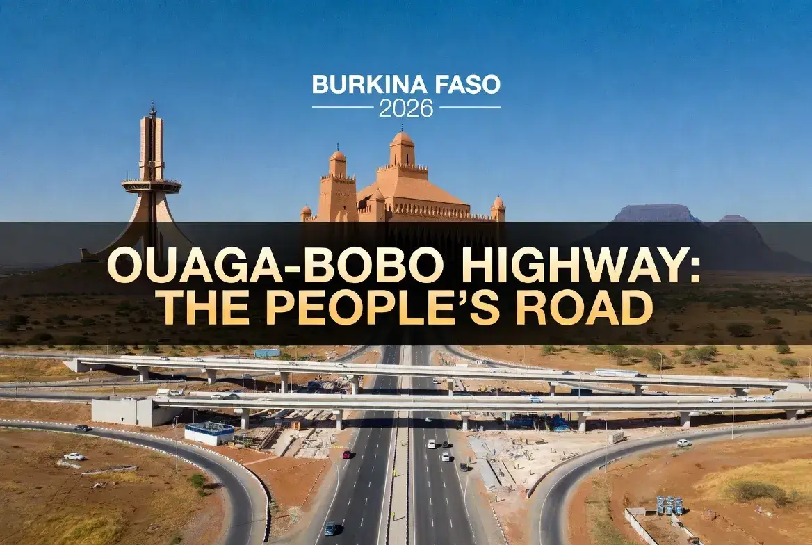
In a transformative development for Burkina Faso's transportation infrastructure, the Ouagadougou-Bobo Dioulasso Highway has emerged as one of West Africa's most significant road projects, with major milestones achieved in 2026. This strategic highway connects the nation's capital, Ouagadougou, to its second-largest city, Bobo-Dioulasso, creating a vital economic corridor that promises to reshape trade, travel, and development across the country.
Stretching approximately 360 kilometers (224 miles) through the heart of Burkina Faso, this modern highway represents far more than just a road—it is a catalyst for economic integration, regional connectivity, and social development. For travelers, business operators, logistics companies, and communities along the route, the completion and opening of this highway in 2026 marks a new era of accessibility, efficiency, and opportunity.
This comprehensive guide provides everything you need to know about the Ouagadougou-Bobo Dioulasso Highway in 2026: from project specifications and construction progress to travel tips, economic impacts, safety considerations, and practical information for using this new travel artery. Whether you're planning a journey between Burkina Faso's two major cities, analyzing infrastructure investment opportunities, or simply interested in West African development, this article equips you with expert, up-to-date information about this landmark infrastructure project.
Project Overview: Scale and Significance
Basic Project Specifications
The Ouagadougou-Bobo Dioulasso Highway is one of Burkina Faso's most ambitious infrastructure undertakings:
- Total Length: Approximately 360 kilometers (224 miles)
- Road Classification: Two-lane highway with provisions for future expansion
- Design Standards: Modern engineering specifications suitable for heavy traffic and commercial vehicles
- Route: Connects Ouagadougou (central Burkina Faso) to Bobo-Dioulasso (southwest)
- Key Towns Served: Koudougou, Boromo, Houndé, and numerous rural communities
- Investment: Multi-hundred million dollar project funded through government and international partnerships
- Construction Period: Phased development with major completion milestones in 2026
- 👉 Ultimate 10 Day Rwanda Itinerary Beyond Gorilla Trekking Volcanoes National Park
- 👉 Hidden Gems of the Quirimbas Archipelago: Complete Guide to Ibo Island's Ruins 2026
- 👉 Chinguetti's Disappearing Libraries: Solo Traveler's Preservation Guide
Strategic Importance
This highway serves as Burkina Faso's primary east-west transportation corridor, with profound implications:
Economic Integration:
- Links the country's administrative capital (Ouagadougou) with its economic and cultural hub (Bobo-Dioulasso)
- Facilitates movement of agricultural products, manufactured goods, and raw materials
- Reduces transportation costs and transit times for businesses
- Stimulates economic activity in towns and villages along the route
- 👉 Ultimate 10 Day Rwanda Itinerary Beyond Gorilla Trekking Volcanoes National Park
- 👉 Hidden Gems of the Quirimbas Archipelago: Complete Guide to Ibo Island's Ruins 2026
- 👉 Chinguetti's Disappearing Libraries: Solo Traveler's Preservation Guide
Regional Connectivity:
- Connects to regional road networks linking Burkina Faso to Côte d'Ivoire, Mali, and Ghana
- Supports trade within the Economic Community of West African States (ECOWAS)
- Enhances Burkina Faso's position as a transit country for landlocked neighbors
- 👉 Ultimate 10 Day Rwanda Itinerary Beyond Gorilla Trekking Volcanoes National Park
- 👉 Hidden Gems of the Quirimbas Archipelago: Complete Guide to Ibo Island's Ruins 2026
- 👉 Chinguetti's Disappearing Libraries: Solo Traveler's Preservation Guide
Social Development:
- Improves access to healthcare, education, and government services for rural communities
- Facilitates movement of people for work, family visits, and cultural exchange
- Supports emergency response and disaster relief operations
- 👉 Ultimate 10 Day Rwanda Itinerary Beyond Gorilla Trekking Volcanoes National Park
- 👉 Hidden Gems of the Quirimbas Archipelago: Complete Guide to Ibo Island's Ruins 2026
- 👉 Chinguetti's Disappearing Libraries: Solo Traveler's Preservation Guide
Construction Progress and 2026 Milestones
Phased Development Approach
The highway project has been implemented in phases to manage complexity and funding:
Phase 1: Ouagadougou to Koudougou (Approximately 100 km)
- Status: Completed and operational
- Features: Paved surface, drainage systems, signage, basic safety features
- Impact: Significant reduction in travel time between Ouagadougou and Koudougou
- 👉 Ultimate 10 Day Rwanda Itinerary Beyond Gorilla Trekking Volcanoes National Park
- 👉 Hidden Gems of the Quirimbas Archipelago: Complete Guide to Ibo Island's Ruins 2026
- 👉 Chinguetti's Disappearing Libraries: Solo Traveler's Preservation Guide
Phase 2: Koudougou to Boromo to Houndé (Approximately 150 km)
- Status: Major sections completed in 2026
- Features: Modern pavement, improved drainage, bridge constructions, rest areas
- Impact: Enhanced connectivity for central Burkina Faso communities
- 👉 Ultimate 10 Day Rwanda Itinerary Beyond Gorilla Trekking Volcanoes National Park
- 👉 Hidden Gems of the Quirimbas Archipelago: Complete Guide to Ibo Island's Ruins 2026
- 👉 Chinguetti's Disappearing Libraries: Solo Traveler's Preservation Guide
Phase 3: Houndé to Bobo-Dioulasso (Approximately 110 km)
- Status: Advanced construction with 2026 completion targets
- Features: Final paving, signage installation, safety barriers, lighting at key intersections
- Impact: Completes the full Ouagadougou-Bobo corridor
- 👉 Ultimate 10 Day Rwanda Itinerary Beyond Gorilla Trekking Volcanoes National Park
- 👉 Hidden Gems of the Quirimbas Archipelago: Complete Guide to Ibo Island's Ruins 2026
- 👉 Chinguetti's Disappearing Libraries: Solo Traveler's Preservation Guide
2026 Completion Milestones
Key achievements marking 2026 as a pivotal year for the project:
- Full Route Paving: Completion of asphalt paving along the entire 360 km corridor
- Bridge Completions: Finalization of major river crossings and overpasses
- Safety Infrastructure: Installation of signage, markings, guardrails, and lighting
- Official Opening: Formal inauguration ceremonies with government and international partners
- Commercial Operations: Full opening to commercial and passenger traffic
- 👉 Ultimate 10 Day Rwanda Itinerary Beyond Gorilla Trekking Volcanoes National Park
- 👉 Hidden Gems of the Quirimbas Archipelago: Complete Guide to Ibo Island's Ruins 2026
- 👉 Chinguetti's Disappearing Libraries: Solo Traveler's Preservation Guide
Construction Challenges and Solutions
The project has navigated several significant challenges:
Security Considerations:
- Construction in regions affected by security challenges required enhanced protection for workers and equipment
- Coordination with security forces to ensure safe working conditions
- Flexible scheduling to adapt to changing security situations
- 👉 Ultimate 10 Day Rwanda Itinerary Beyond Gorilla Trekking Volcanoes National Park
- 👉 Hidden Gems of the Quirimbas Archipelago: Complete Guide to Ibo Island's Ruins 2026
- 👉 Chinguetti's Disappearing Libraries: Solo Traveler's Preservation Guide
Environmental and Social Management:
- Environmental impact assessments and mitigation measures
- Community consultation and compensation for affected landowners
- Protection of water sources and agricultural land
- 👉 Ultimate 10 Day Rwanda Itinerary Beyond Gorilla Trekking Volcanoes National Park
- 👉 Hidden Gems of the Quirimbas Archipelago: Complete Guide to Ibo Island's Ruins 2026
- 👉 Chinguetti's Disappearing Libraries: Solo Traveler's Preservation Guide
Technical and Logistical Challenges:
- Sourcing quality construction materials in a landlocked country
- Managing construction during rainy seasons
- Coordinating multiple contractors and work zones
- 👉 Ultimate 10 Day Rwanda Itinerary Beyond Gorilla Trekking Volcanoes National Park
- 👉 Hidden Gems of the Quirimbas Archipelago: Complete Guide to Ibo Island's Ruins 2026
- 👉 Chinguetti's Disappearing Libraries: Solo Traveler's Preservation Guide
Travel Information: Using the New Highway
Route Overview and Key Points
Travelers using the Ouagadougou-Bobo Dioulasso Highway will pass through diverse landscapes and communities:
Starting Point: Ouagadougou
- Access: Highway begins at major interchange on Ouagadougou's southwestern periphery
- Connections: Links to city center, airport, and other national highways
- Services: Fuel stations, restaurants, vehicle services available near departure point
- 👉 Ultimate 10 Day Rwanda Itinerary Beyond Gorilla Trekking Volcanoes National Park
- 👉 Hidden Gems of the Quirimbas Archipelago: Complete Guide to Ibo Island's Ruins 2026
- 👉 Chinguetti's Disappearing Libraries: Solo Traveler's Preservation Guide
Major Stops Along the Route:
Koudougou (Approximately 100 km from Ouagadougou):
- Significance: Third-largest city in Burkina Faso; important commercial center
- Services: Fuel, food, accommodation, vehicle repair
- Attractions: Traditional architecture, local markets, cultural sites
- 👉 Ultimate 10 Day Rwanda Itinerary Beyond Gorilla Trekking Volcanoes National Park
- 👉 Hidden Gems of the Quirimbas Archipelago: Complete Guide to Ibo Island's Ruins 2026
- 👉 Chinguetti's Disappearing Libraries: Solo Traveler's Preservation Guide
Boromo (Approximately 170 km from Ouagadougou):
- Significance: Agricultural hub; gateway to nearby natural areas
- Services: Basic fuel and food services
- Nearby: Access to rural communities and agricultural areas
- 👉 Ultimate 10 Day Rwanda Itinerary Beyond Gorilla Trekking Volcanoes National Park
- 👉 Hidden Gems of the Quirimbas Archipelago: Complete Guide to Ibo Island's Ruins 2026
- 👉 Chinguetti's Disappearing Libraries: Solo Traveler's Preservation Guide
Houndé (Approximately 250 km from Ouagadougou):
- Significance: Gold mining region; growing commercial center
- Services: Fuel, food, accommodation, banking services
- Economic Activity: Mining-related commerce and services
- 👉 Ultimate 10 Day Rwanda Itinerary Beyond Gorilla Trekking Volcanoes National Park
- 👉 Hidden Gems of the Quirimbas Archipelago: Complete Guide to Ibo Island's Ruins 2026
- 👉 Chinguetti's Disappearing Libraries: Solo Traveler's Preservation Guide
Destination: Bobo-Dioulasso (Approximately 360 km from Ouagadougou)
- Significance: Burkina Faso's second-largest city; cultural and economic hub
- Access: Highway connects to city center and regional road networks
- Services: Full range of urban services including hotels, restaurants, vehicle services
- Connections: Links to routes toward Côte d'Ivoire and other regional destinations
- 👉 Ultimate 10 Day Rwanda Itinerary Beyond Gorilla Trekking Volcanoes National Park
- 👉 Hidden Gems of the Quirimbas Archipelago: Complete Guide to Ibo Island's Ruins 2026
- 👉 Chinguetti's Disappearing Libraries: Solo Traveler's Preservation Guide
Travel Times and Conditions
Estimated Travel Times:
- Ouagadougou to Bobo-Dioulasso: Approximately 4-5 hours under normal conditions
- Ouagadougou to Koudougou: Approximately 1.5 hours
- Koudougou to Bobo-Dioulasso: Approximately 3-3.5 hours
- 👉 Ultimate 10 Day Rwanda Itinerary Beyond Gorilla Trekking Volcanoes National Park
- 👉 Hidden Gems of the Quirimbas Archipelago: Complete Guide to Ibo Island's Ruins 2026
- 👉 Chinguetti's Disappearing Libraries: Solo Traveler's Preservation Guide
Factors Affecting Travel Time:
- Traffic: Commercial vehicles, especially during market days
- Weather: Rainy season (June-September) may cause temporary delays
- Road Conditions: Ongoing maintenance or construction may cause brief slowdowns
- Security: Occasional checkpoints or security operations may cause brief stops
- 👉 Ultimate 10 Day Rwanda Itinerary Beyond Gorilla Trekking Volcanoes National Park
- 👉 Hidden Gems of the Quirimbas Archipelago: Complete Guide to Ibo Island's Ruins 2026
- 👉 Chinguetti's Disappearing Libraries: Solo Traveler's Preservation Guide
Road Conditions and Features
Surface and Design:
- Pavement: Modern asphalt surface suitable for all vehicle types
- Lanes: Two lanes (one in each direction) with shoulders for emergency stopping
- Shoulders: Paved or gravel shoulders for breakdowns and emergency access
- Drainage: Improved drainage systems to handle seasonal rainfall
- 👉 Ultimate 10 Day Rwanda Itinerary Beyond Gorilla Trekking Volcanoes National Park
- 👉 Hidden Gems of the Quirimbas Archipelago: Complete Guide to Ibo Island's Ruins 2026
- 👉 Chinguetti's Disappearing Libraries: Solo Traveler's Preservation Guide
Safety Features:
- Signage: International-standard road signs in French (distance markers, warnings, directions)
- Markings: Center lines, edge lines, and pedestrian crossing markings
- Guardrails: Safety barriers at bridges, sharp curves, and hazardous sections
- Lighting: Street lighting at major intersections and town approaches
- Rest Areas: Designated stopping points with basic facilities
- 👉 Ultimate 10 Day Rwanda Itinerary Beyond Gorilla Trekking Volcanoes National Park
- 👉 Hidden Gems of the Quirimbas Archipelago: Complete Guide to Ibo Island's Ruins 2026
- 👉 Chinguetti's Disappearing Libraries: Solo Traveler's Preservation Guide
Economic and Social Impact
Transportation Efficiency Gains
The new highway delivers substantial improvements in transportation efficiency:
- Time Savings: Reduced travel time from 6-8 hours on the old road to 4-5 hours on the new highway
- Vehicle Operating Costs: Lower fuel consumption and reduced vehicle wear on improved surface
- Reliability: All-weather accessibility reduces disruptions from rain and poor road conditions
- Capacity: Ability to handle increased traffic volumes supports economic growth
- 👉 Ultimate 10 Day Rwanda Itinerary Beyond Gorilla Trekking Volcanoes National Park
- 👉 Hidden Gems of the Quirimbas Archipelago: Complete Guide to Ibo Island's Ruins 2026
- 👉 Chinguetti's Disappearing Libraries: Solo Traveler's Preservation Guide
Economic Benefits
The highway catalyzes economic development across multiple sectors:
Agriculture:
- Faster transport of perishable crops to markets reduces post-harvest losses
- Lower transportation costs improve farmer incomes
- Improved access to inputs (seeds, fertilizer, equipment) supports productivity
- 👉 Ultimate 10 Day Rwanda Itinerary Beyond Gorilla Trekking Volcanoes National Park
- 👉 Hidden Gems of the Quirimbas Archipelago: Complete Guide to Ibo Island's Ruins 2026
- 👉 Chinguetti's Disappearing Libraries: Solo Traveler's Preservation Guide
Trade and Commerce:
- Enhanced movement of goods between Burkina Faso's major economic centers
- Reduced costs for businesses relying on road transport
- Improved connectivity to regional markets via connections to Côte d'Ivoire and Ghana
- 👉 Ultimate 10 Day Rwanda Itinerary Beyond Gorilla Trekking Volcanoes National Park
- 👉 Hidden Gems of the Quirimbas Archipelago: Complete Guide to Ibo Island's Ruins 2026
- 👉 Chinguetti's Disappearing Libraries: Solo Traveler's Preservation Guide
Employment:
- Direct jobs in highway maintenance and operations
- Indirect jobs in transportation, logistics, and roadside services
- Induced employment from economic growth stimulated by improved connectivity
- 👉 Ultimate 10 Day Rwanda Itinerary Beyond Gorilla Trekking Volcanoes National Park
- 👉 Hidden Gems of the Quirimbas Archipelago: Complete Guide to Ibo Island's Ruins 2026
- 👉 Chinguetti's Disappearing Libraries: Solo Traveler's Preservation Guide
Community Development
Rural communities along the highway benefit in multiple ways:
- Market Access: Farmers and artisans can reach larger markets more easily
- Service Access: Improved access to healthcare, education, and government services
- Entrepreneurship: New opportunities for roadside businesses (fuel, food, repairs)
- Social Connectivity: Easier travel for family visits, cultural events, and community exchange
- 👉 Ultimate 10 Day Rwanda Itinerary Beyond Gorilla Trekking Volcanoes National Park
- 👉 Hidden Gems of the Quirimbas Archipelago: Complete Guide to Ibo Island's Ruins 2026
- 👉 Chinguetti's Disappearing Libraries: Solo Traveler's Preservation Guide
Services and Facilities Along the Route
Fuel and Vehicle Services
Fuel Stations:
- Major Towns: Full-service stations in Ouagadougou, Koudougou, Boromo, Houndé, and Bobo-Dioulasso
- Intermediate Points: Basic fuel availability at strategic points along the route
- Fuel Types: Gasoline and diesel widely available; confirm availability for specialized fuels
- Payment: Cash (CFA francs) preferred; some stations accept cards
- 👉 Ultimate 10 Day Rwanda Itinerary Beyond Gorilla Trekking Volcanoes National Park
- 👉 Hidden Gems of the Quirimbas Archipelago: Complete Guide to Ibo Island's Ruins 2026
- 👉 Chinguetti's Disappearing Libraries: Solo Traveler's Preservation Guide
Vehicle Repair and Maintenance:
- Major Towns: Full-service garages and repair shops
- Emergency Assistance: Basic repair services at intermediate points
- Tire Services: Tire repair and replacement available in towns
- Recommendation: Ensure vehicle is in good condition before long journeys
- 👉 Ultimate 10 Day Rwanda Itinerary Beyond Gorilla Trekking Volcanoes National Park
- 👉 Hidden Gems of the Quirimbas Archipelago: Complete Guide to Ibo Island's Ruins 2026
- 👉 Chinguetti's Disappearing Libraries: Solo Traveler's Preservation Guide
Food and Accommodation
Restaurants and Food Services:
- Major Towns: Variety of dining options from local cuisine to international fare
- Roadside: Simple eateries offering grilled meats, rice dishes, and local specialties
- Hygiene: Choose busy establishments with high food turnover for better safety
- Water: Drink only bottled or treated water
- 👉 Ultimate 10 Day Rwanda Itinerary Beyond Gorilla Trekking Volcanoes National Park
- 👉 Hidden Gems of the Quirimbas Archipelago: Complete Guide to Ibo Island's Ruins 2026
- 👉 Chinguetti's Disappearing Libraries: Solo Traveler's Preservation Guide
Accommodation Options:
- Ouagadougou and Bobo-Dioulasso: Full range from budget to upscale hotels
- Koudougou and Houndé: Mid-range and budget hotels suitable for overnight stops
- Intermediate Points: Basic guesthouses and lodges for emergency overnight stays
- Booking: Advance booking recommended for major towns, especially during peak travel periods
- 👉 Ultimate 10 Day Rwanda Itinerary Beyond Gorilla Trekking Volcanoes National Park
- 👉 Hidden Gems of the Quirimbas Archipelago: Complete Guide to Ibo Island's Ruins 2026
- 👉 Chinguetti's Disappearing Libraries: Solo Traveler's Preservation Guide
Communication and Connectivity
- Mobile Coverage: Generally good coverage along the highway from major providers (Orange, Telecel, Moov)
- Internet: Mobile data available; speeds vary by location
- Emergency Numbers: Save local emergency contacts before traveling
- Recommendation: Inform someone of your travel plans and expected arrival time
- 👉 Ultimate 10 Day Rwanda Itinerary Beyond Gorilla Trekking Volcanoes National Park
- 👉 Hidden Gems of the Quirimbas Archipelago: Complete Guide to Ibo Island's Ruins 2026
- 👉 Chinguetti's Disappearing Libraries: Solo Traveler's Preservation Guide
Safety and Security Considerations
Road Safety
Driving Practices:
- Speed Limits: Observe posted limits; typically 80-100 km/h on open highway sections
- Overtaking: Exercise extreme caution; only overtake when visibility is clear and safe
- Night Driving: Avoid if possible due to limited lighting and increased risks
- Vehicle Condition: Ensure tires, brakes, lights, and fluids are in good condition
- 👉 Ultimate 10 Day Rwanda Itinerary Beyond Gorilla Trekking Volcanoes National Park
- 👉 Hidden Gems of the Quirimbas Archipelago: Complete Guide to Ibo Island's Ruins 2026
- 👉 Chinguetti's Disappearing Libraries: Solo Traveler's Preservation Guide
Common Hazards:
- Pedestrians and Animals: Watch for pedestrians, cyclists, and livestock near villages
- Commercial Vehicles: Maintain safe following distance from trucks and buses
- Weather: Reduce speed during rain; watch for standing water and reduced visibility
- Road Users: Be alert for motorcycles, bicycles, and animal-drawn carts
- 👉 Ultimate 10 Day Rwanda Itinerary Beyond Gorilla Trekking Volcanoes National Park
- 👉 Hidden Gems of the Quirimbas Archipelago: Complete Guide to Ibo Island's Ruins 2026
- 👉 Chinguetti's Disappearing Libraries: Solo Traveler's Preservation Guide
Security Considerations
General Security:
- Checkpoints: Expect occasional security checkpoints; have identification ready
- Travel Documents: Carry passport, visa, and vehicle documents at all times
- Valuables: Keep valuables out of sight; avoid displaying expensive items
- Local Advice: Seek current security advice from local authorities or trusted contacts
- 👉 Ultimate 10 Day Rwanda Itinerary Beyond Gorilla Trekking Volcanoes National Park
- 👉 Hidden Gems of the Quirimbas Archipelago: Complete Guide to Ibo Island's Ruins 2026
- 👉 Chinguetti's Disappearing Libraries: Solo Traveler's Preservation Guide
Regional Security Context:
- Burkina Faso faces security challenges in certain regions; the Ouagadougou-Bobo corridor is generally considered one of the more stable routes
- Security situations can change; check current travel advisories before traveling
- Consider traveling in convoy for added security, especially for commercial shipments
- Register with your embassy if traveling as a foreign national
- 👉 Ultimate 10 Day Rwanda Itinerary Beyond Gorilla Trekking Volcanoes National Park
- 👉 Hidden Gems of the Quirimbas Archipelago: Complete Guide to Ibo Island's Ruins 2026
- 👉 Chinguetti's Disappearing Libraries: Solo Traveler's Preservation Guide
Practical Travel Tips
Before You Travel
- Vehicle Preparation: Service your vehicle; check tires, brakes, fluids, and lights
- Documents: Ensure passport, visa, driver's license, and vehicle registration are valid and accessible
- Supplies: Carry water, snacks, basic first aid kit, and emergency supplies
- Communication: Ensure mobile phone is charged; carry backup power source
- Weather Check: Check forecast; postpone travel if heavy rain is expected
- Route Planning: Identify fuel stops, rest areas, and overnight options in advance
- 👉 Ultimate 10 Day Rwanda Itinerary Beyond Gorilla Trekking Volcanoes National Park
- 👉 Hidden Gems of the Quirimbas Archipelago: Complete Guide to Ibo Island's Ruins 2026
- 👉 Chinguetti's Disappearing Libraries: Solo Traveler's Preservation Guide
During the Journey
- Start Early: Begin travel in morning daylight for safest conditions
- Regular Breaks: Stop every 2-3 hours to rest and maintain alertness
- Stay Alert: Watch for changing road conditions, other vehicles, and pedestrians
- Fuel Management: Refuel when tank reaches half; don't wait until nearly empty
- Local Customs: Respect local communities; ask permission before photographing people
- Flexibility: Allow extra time for unexpected delays or stops
- 👉 Ultimate 10 Day Rwanda Itinerary Beyond Gorilla Trekking Volcanoes National Park
- 👉 Hidden Gems of the Quirimbas Archipelago: Complete Guide to Ibo Island's Ruins 2026
- 👉 Chinguetti's Disappearing Libraries: Solo Traveler's Preservation Guide
For Commercial Operators
- Load Security: Ensure cargo is properly secured and documented
- Driver Rest: Comply with rest requirements; avoid driver fatigue
- Route Coordination: Coordinate with receivers on expected arrival times
- Security Protocols: Follow company security procedures for high-value shipments
- 👉 Ultimate 10 Day Rwanda Itinerary Beyond Gorilla Trekking Volcanoes National Park
- 👉 Hidden Gems of the Quirimbas Archipelago: Complete Guide to Ibo Island's Ruins 2026
- 👉 Chinguetti's Disappearing Libraries: Solo Traveler's Preservation Guide
Environmental and Sustainability Considerations
Environmental Management During Construction
The highway project incorporated environmental safeguards:
- Impact Assessments: Environmental and social impact assessments guided project design
- Erosion Control: Measures to prevent soil erosion during and after construction
- Water Protection: Protection of water sources and drainage management
- Vegetation: Efforts to minimize tree removal and restore vegetation where possible
- 👉 Ultimate 10 Day Rwanda Itinerary Beyond Gorilla Trekking Volcanoes National Park
- 👉 Hidden Gems of the Quirimbas Archipelago: Complete Guide to Ibo Island's Ruins 2026
- 👉 Chinguetti's Disappearing Libraries: Solo Traveler's Preservation Guide
Sustainable Operation
- Maintenance: Regular maintenance extends road life and reduces long-term environmental impact
- Emissions: Improved road conditions can reduce vehicle emissions through more efficient driving
- Community Engagement: Ongoing dialogue with communities along the route
- 👉 Ultimate 10 Day Rwanda Itinerary Beyond Gorilla Trekking Volcanoes National Park
- 👉 Hidden Gems of the Quirimbas Archipelago: Complete Guide to Ibo Island's Ruins 2026
- 👉 Chinguetti's Disappearing Libraries: Solo Traveler's Preservation Guide
Future Developments and Expansion Plans
Potential Upgrades
While the highway is newly completed, future enhancements may include:
- Capacity Expansion: Potential for additional lanes as traffic volumes grow
- Safety Enhancements: Additional lighting, signage, and safety features
- Service Areas: Development of full-service rest areas with fuel, food, and facilities
- Technology Integration: Potential for traffic monitoring, electronic signage, and communication systems
- 👉 Ultimate 10 Day Rwanda Itinerary Beyond Gorilla Trekking Volcanoes National Park
- 👉 Hidden Gems of the Quirimbas Archipelago: Complete Guide to Ibo Island's Ruins 2026
- 👉 Chinguetti's Disappearing Libraries: Solo Traveler's Preservation Guide
Regional Integration
- Connections to Neighboring Countries: The highway supports broader regional road networks linking Burkina Faso to Côte d'Ivoire, Mali, and Ghana
- Trade Corridors: Contributes to ECOWAS trade corridor development
- Transit Traffic: Supports Burkina Faso's role as a transit country for landlocked neighbors
- 👉 Ultimate 10 Day Rwanda Itinerary Beyond Gorilla Trekking Volcanoes National Park
- 👉 Hidden Gems of the Quirimbas Archipelago: Complete Guide to Ibo Island's Ruins 2026
- 👉 Chinguetti's Disappearing Libraries: Solo Traveler's Preservation Guide
Frequently Asked Questions (FAQs)
Q: Is the Ouagadougou-Bobo Dioulasso Highway fully open to traffic in 2026?
A: Yes, major sections of the highway were completed and opened to traffic in 2026, with the full corridor operational. However, travelers should check for any temporary closures due to maintenance or security before traveling.
Q: How long does it take to drive from Ouagadougou to Bobo-Dioulasso?
A: Under normal conditions, the journey takes approximately 4-5 hours on the new highway, compared to 6-8 hours on the old road.
Q: Are there fuel stations along the highway?
A: Yes, fuel stations are available in major towns (Ouagadougou, Koudougou, Boromo, Houndé, Bobo-Dioulasso) and at strategic intermediate points. It's advisable to refuel when your tank reaches half capacity.
Q: Is the highway safe to travel at night?
A: Night travel is generally not recommended due to limited lighting, increased risk of encountering unlit vehicles or pedestrians, and security considerations. Plan to travel during daylight hours when possible.
Q: What documents do I need to travel this highway?
A: Carry valid identification (passport for foreigners, national ID for citizens), driver's license, vehicle registration, and insurance documents. Foreign travelers should also carry visa documentation.
Q: Are there accommodations along the route?
A: Yes, accommodations are available in major towns along the route. For intermediate points, basic guesthouses may be available, but advance planning is recommended for overnight stops.
Q: What should I do if my vehicle breaks down?
A: Pull over to a safe location if possible, use hazard lights, and contact roadside assistance if available. Carry basic emergency supplies and a charged mobile phone. In remote areas, seek assistance from passing vehicles or nearby communities.
Q: Is the highway toll-free?
A: As of 2026, the Ouagadougou-Bobo Dioulasso Highway does not have tolls. However, this may change in the future; check current information before traveling.
Q: Can I use the highway for commercial transport?
A: Yes, the highway is designed to accommodate commercial vehicles. Commercial operators should ensure vehicles meet weight and safety requirements and comply with any applicable regulations.
Q: What is the best time of year to travel this highway?
A: The dry season (November to April) offers the most reliable travel conditions. During the rainy season (June to September), be prepared for potential delays due to heavy rain, though the highway's improved drainage minimizes disruptions.
Conclusion: A New Era of Connectivity for Burkina Faso
The completion and opening of the Ouagadougou-Bobo Dioulasso Highway in 2026 represents far more than a transportation project—it is a transformative investment in Burkina Faso's future. By connecting the nation's two largest cities with a modern, efficient, and safe roadway, this highway unlocks economic potential, strengthens social ties, and enhances Burkina Faso's integration into regional and global networks.
For travelers, the highway offers a faster, more comfortable, and more reliable journey between Ouagadougou and Bobo-Dioulasso. For businesses, it reduces costs, improves supply chain efficiency, and opens new market opportunities. For communities along the route, it brings improved access to services, markets, and opportunities for development.
As with any major infrastructure project, the highway's full benefits will unfold over time, requiring continued investment in maintenance, safety, and complementary development. But the foundation laid in 2026 positions Burkina Faso for a more connected, prosperous, and resilient future.
Whether you're embarking on a personal journey, managing commercial logistics, or simply observing West Africa's development, the Ouagadougou-Bobo Dioulasso Highway stands as a testament to what can be achieved through vision, partnership, and commitment to progress. As you travel this new artery, you're not just moving from one city to another—you're participating in Burkina Faso's ongoing story of growth and transformation.
Travel safely. Travel wisely. Experience the new connection that is driving Burkina Faso forward.
Disclaimer: Information provided is based on available data as of early 2026. Road conditions, security situations, and service availability can change. Always verify current information through official Burkinabè government sources, local authorities, and trusted travel advisories before traveling. Security conditions in Burkina Faso can be volatile; consult your government's travel advisories and exercise appropriate caution. This guide is for informational purposes only and does not constitute official travel advice.
0 Comments