.webp)
.webp)
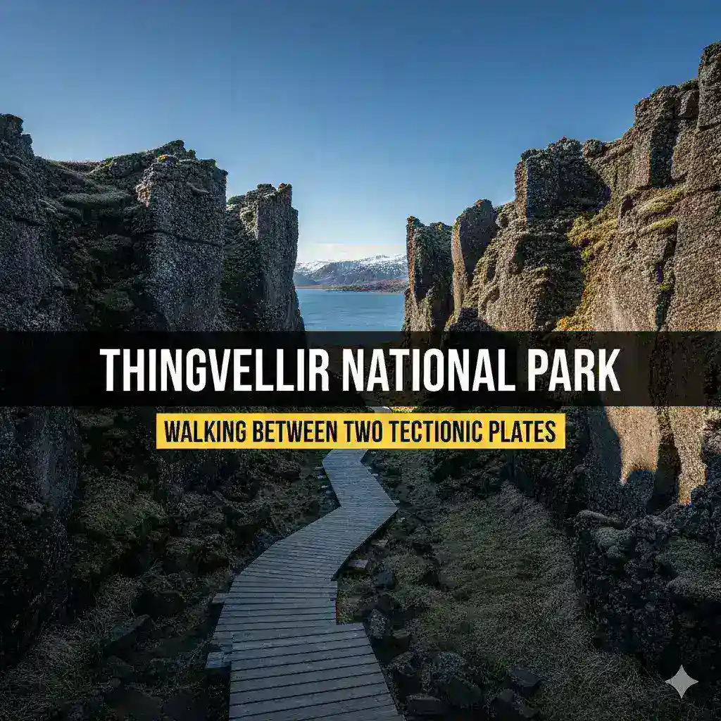
ÞINGVELLIR NATIONAL PARK: WALKING BETWEEN TWO TECTONIC PLATES (UNESCO)
Þingvellir (Thingvellir) National Park stands as one of Earth's most extraordinary destinations—a place where you can literally walk between two continents, where ancient tectonic plates diverge before your eyes, and where over a millennium ago, Viking chieftains gathered to establish one of the world's oldest parliaments. Designated as Iceland's first national park in 1930 and inscribed as a UNESCO World Heritage Site in 2004, Þingvellir represents a rare convergence of profound geological significance and unparalleled cultural heritage. Located approximately 40 kilometers (25 miles) northeast of Reykjavik, this remarkable landscape offers visitors the unique opportunity to witness continental drift in action while exploring the birthplace of Icelandic democracy.
In 2026, as travelers seek destinations that combine natural wonder, historical depth, and authentic cultural experiences, Þingvellir National Park remains an essential Iceland experience. Whether you are a geology enthusiast fascinated by plate tectonics and volcanic landscapes, a history lover drawn by Viking-age assembly grounds and medieval law-making, a photography enthusiast chasing dramatic rift valley light and crystal-clear waters, an adventure seeker eager to snorkel between continents in Silfra fissure, or simply a curious traveler inspired by a landscape where Earth's forces and human history intertwine, this comprehensive guide will help you prepare for an unforgettable encounter with this remarkable UNESCO World Heritage Site.
Understanding Þingvellir requires more than visiting famous landmarks; it demands engaging with the geological forces that continue to shape this dynamic landscape, appreciating the cultural significance of sites where Iceland's democracy was born, and respecting the raw power of natural phenomena that have drawn visitors for centuries. By approaching Þingvellir with curiosity and respect, you will discover not just spectacular sights but a living dialogue between fire and ice, between ancient history and geological present, between human culture and elemental nature.
GEOLOGICAL WONDER: WHERE CONTINENTS DIVERGE
Þingvellir's most extraordinary feature is its position within the Mid-Atlantic Ridge, where the North American and Eurasian tectonic plates are pulling apart at approximately 2 centimeters (0.8 inches) per year.
The Tectonic Rift:
Visible Continental Drift:
- Almannagjá Gorge: This dramatic rift valley provides a walkable example of continental separation, where you can literally stand with one foot on the North American plate and the other on the Eurasian plate
- Geological Process: As the plates diverge, magma rises from the mantle to fill the gap, creating new crust and shaping Iceland's landscape
- Visible Evidence: Numerous fissures, caves, and rock formations throughout the park demonstrate the ongoing geological activity
Silfra Fissure:
- Crystal-Clear Waters: Fed by glacial meltwater filtered through porous lava rock for decades, Silfra offers visibility exceeding 100 meters (330 feet)
- Diving and Snorkeling: One of the world's premier locations for swimming between tectonic plates; water temperature remains 2-4°C (35-39°F) year-round
- Geological Significance: The fissure continues to widen as the plates separate, creating new underwater landscapes
Volcanic Landscape:
Þingvellir's geology tells the story of Iceland's formation:
- Basalt Formations: Hexagonal basalt columns and layered lava flows reveal the park's volcanic origins
- Fault Lines: Numerous visible faults and fissures demonstrate the ongoing tectonic activity
- Earthquake Activity: The park experiences frequent small earthquakes as the plates continue to move
HISTORICAL SIGNIFICANCE: BIRTHPLACE OF ICELANDIC DEMOCRACY
Þingvellir's cultural importance rivals its geological significance, as the site of Iceland's ancient parliament and national assembly.
The Alþingi (Althing):
Founding and Purpose:
- 930 CE: Iceland's parliament, the Alþingi, was established at Þingvellir, making it one of the world's oldest surviving parliamentary institutions
- Annual Assembly: For over 800 years, chieftains (goðar) and free farmers gathered here each June to make laws, settle disputes, and shape Icelandic society
- Legal Code: The assembly developed Iceland's early legal system, including the innovative concept that all free men were equal before the law
Historical Events:
- Conversion to Christianity (1000 CE): At Þingvellir, Icelanders made the pivotal decision to convert from Norse paganism to Christianity, avoiding civil war through compromise
- Commonwealth Period: Þingvellir served as the political and judicial center of the Icelandic Commonwealth until the 13th century
- Norwegian and Danish Rule: The Alþingi continued to meet at Þingvellir under foreign rule until 1798, when it was moved to Reykjavik
National Symbol:
- Independence Movement: In the 19th and 20th centuries, Þingvellir became a powerful symbol of Icelandic national identity and the struggle for independence
- 1944 Declaration: Iceland's full independence from Denmark was proclaimed at Þingvellir on June 17, 1944
- Modern Democracy: The Alþingi continues to function today as Iceland's parliament, maintaining an unbroken tradition of representative government
UNESCO WORLD HERITAGE DESIGNATION
Þingvellir's dual significance earned it UNESCO World Heritage status in 2004:
Criteria for Inscription:
- Cultural Criterion (iii): Þingvellir bears exceptional testimony to the cultural tradition of the Alþingi and the development of Icelandic society
- Natural Criterion (vii): The park contains superlative natural phenomena and areas of exceptional natural beauty
- Natural Criterion (viii): Þingvellir is an outstanding example of major stages of Earth's history, including ongoing geological processes
Conservation and Management:
- Protected Status: As a national park and UNESCO site, Þingvellir receives special protection and management
- Sustainable Tourism: Visitor facilities and trails are designed to minimize impact on fragile ecosystems
- Educational Mission: The park serves as an outdoor classroom for geology, history, and environmental stewardship
KEY ATTRACTIONS AND EXPERIENCES
Þingvellir offers numerous attractions that showcase its geological and cultural significance.
Almannagjá Gorge:
The park's most iconic geological feature:
- Walking the Rift: A well-maintained path allows visitors to walk through the dramatic gorge, with towering basalt cliffs on either side
- Geological Interpretation: Informational signs explain the tectonic processes that formed the rift
- Photography Opportunities: Dramatic rock formations, play of light and shadow, and the sense of walking between continents
Öxarárfoss Waterfall:
A picturesque cascade within the rift valley:
- Access: Short, easy walk from the main parking area to viewing platforms
- Features: The waterfall plunges approximately 20 meters (65 feet) into the Almannagjá gorge
- Historical Note: The river was artificially diverted to create the waterfall in the 10th century to provide water for the Alþingi assembly
- Photography: Long exposure techniques create silky water effects; rainbow possibilities on sunny days
Silfra Fissure:
World-renowned diving and snorkeling destination:
- Snorkeling Tours: Guided tours available for certified snorkelers; dry suits provided for cold water
- Diving Certification: Advanced certification required for scuba diving; tours include equipment and guidance
- Underwater Visibility: Exceptional clarity allows observation of underwater geological formations
- Booking: Advance reservation essential; tours operate year-round with seasonal variations
Þingvallavatn Lake:
Iceland's largest natural lake:
- Size: Approximately 84 square kilometers (32 square miles)
- Activities: Fishing (particularly for brown trout and Arctic char), boating, and lakeside hiking
- Scenic Beauty: The lake's shores offer beautiful views of surrounding mountains and volcanic landscapes
- Ecological Importance: Important habitat for birds and aquatic species
Visitor Center and Exhibits:
Educational resources for understanding Þingvellir:
- Geological Exhibits: Interactive displays explaining plate tectonics, volcanic activity, and Iceland's formation
- Historical Exhibits: Artifacts, reconstructions, and multimedia presentations about the Alþingi and Viking Age Iceland
- Film Presentation: Short documentary about Þingvellir's significance (available in multiple languages)
- Facilities: Restrooms, café, gift shop, and information desk with knowledgeable staff
Hiking Trails:
Extensive trail network for exploring the park:
- Öxarárfoss Trail: Easy 1.2 km (0.75 mile) round trip to the waterfall
- Almannagjá Trail: Moderate 2 km (1.2 mile) walk through the rift valley
- Lake Shore Trail: Longer trails along Þingvallavatn for birdwatching and photography
- Difficulty Levels: Trails range from easy, paved paths to more challenging backcountry routes
- Trail Maps: Available at visitor center and online; download offline maps for areas with limited cell service
VISITING ÞINGVELLIR: PRACTICAL INFORMATION FOR 2026
Planning your visit to Þingvellir requires understanding current policies, hours, and protocols to make the most of your experience.
Opening Hours and Access:
Park Access:
- Year-Round: Þingvellir National Park is open 24/7, year-round
- Visitor Center Hours: Typically 9:00 AM - 5:00 PM (summer); 10:00 AM - 4:00 PM (winter); verify current schedule
- Seasonal Variations: Some facilities may have reduced hours in winter; check official website before visiting
Admission and Fees:
Park Entry:
- Free Admission: Entry to Þingvellir National Park is free for all visitors
- Parking Fees: Small parking fee may apply at main lots (approximately €5-10); helps fund maintenance
- Activity Fees: Guided tours (Silfra snorkeling/diving, guided hikes) have separate fees
Silfra Snorkeling/Diving:
- Cost: Snorkeling tours approximately €100-150; diving tours €150-250
- Inclusions: Dry suit, equipment, guide, and transportation from Reykjavik (varies by operator)
- Booking: Reserve well in advance, especially for summer and weekend dates
Best Time to Visit:
Seasonal Considerations:
Summer (June-August):
- Advantages: Long daylight hours (midnight sun), mild temperatures, all facilities open, accessible trails
- Disadvantages: Peak tourist crowds, higher prices for tours and accommodations
- Weather: 10-15°C (50-59°F); can be windy and changeable
- Daylight: 18-24 hours of daylight; ideal for photography and extended exploration
Shoulder Seasons (May and September-October):
- Advantages: Fewer crowds, lower prices, good balance of daylight and darkness, possible Northern Lights in late season
- Disadvantages: More variable weather, some facilities may have reduced hours
- Weather: 5-10°C (41-50°F); unpredictable
- Daylight: 10-16 hours
Winter (November-April):
- Advantages: Fewest crowds, lowest prices, Northern Lights possible, dramatic winter landscapes, ice caves accessible
- Disadvantages: Limited daylight, challenging weather conditions, some trails may be closed or require special equipment
- Weather: -5 to 5°C (23-41°F); can be harsh with snow and ice
- Daylight: 4-8 hours (as little as 4 hours in December)
Recommended Duration:
Half-Day Visit (3-4 hours):
- Focus: Almannagjá gorge, Öxarárfoss waterfall, visitor center
- Best For: Golden Circle day trips, travelers with limited time
- Pace: Moderate; allows time for photography and short hikes
Full-Day Visit (6-8 hours):
- Focus: Comprehensive exploration including Silfra activity, longer hikes, and multiple viewpoints
- Best For: Photography enthusiasts, geology/history buffs, those wanting deeper experience
- Pace: Relaxed; allows time for multiple activities and contemplation
Getting to Þingvellir:
From Reykjavik:
- Distance: Approximately 40 kilometers (25 miles) northeast of Reykjavik
- Route: Take Route 1 (Ring Road) east, then Route 36 north directly to Þingvellir
- Driving Time: 45-60 minutes from central Reykjavik
- Road Conditions: Well-maintained paved road; suitable for all vehicles in summer; 4WD recommended in winter
By Car (Self-Drive):
- Advantages: Flexibility to explore at your own pace, stop for photos, and visit additional attractions
- Parking: Multiple parking areas throughout the park; follow signs for specific attractions
- Navigation: GPS or smartphone with offline maps; roads are well-signed
By Guided Tour:
- Options: Golden Circle tours typically include Þingvellir as first stop; specialized geology/history tours available
- Advantages: Expert commentary, no driving stress, all logistics handled
- Disadvantages: Fixed schedule, less flexibility, must keep up with group
By Public Transport:
- Limited Options: Public bus service to Þingvellir is infrequent; not practical for most visitors
- Recommendation: Self-drive or guided tour strongly recommended for accessibility and convenience
Accessibility Considerations:
Mobility Access:
- Main Areas: Visitor center, main parking areas, and paths to Öxarárfoss are wheelchair accessible
- Almannagjá Gorge: Some sections accessible; other parts have uneven terrain and stairs
- Silfra: Snorkeling/diving requires physical fitness; not suitable for those with significant mobility limitations
Sensory Considerations:
- Wind and Weather: Park can be windy and cold even in summer; dress in layers
- Noise Levels: Generally quiet and peaceful; ideal for those seeking natural tranquility
- Visual Accessibility: Dramatic landscapes provide excellent visual experiences; audio guides available at visitor center
PHOTOGRAPHY TIPS: CAPTURING ÞINGVELLIR'S UNIQUE LANDSCAPE
Þingvellir offers exceptional photography opportunities, with dramatic geological formations, historic sites, and ever-changing light.
Best Photography Locations:
Almannagjá Gorge:
- Rift Valley Perspectives: Wide-angle shots emphasizing the scale of continental separation
- Rock Textures: Close-ups of basalt columns, lichen-covered surfaces, and geological layers
- Light and Shadow: Dramatic contrasts created by low-angle sunlight, especially in morning and evening
Öxarárfoss Waterfall:
- Long Exposure: 1-2 second exposures create silky water effects; tripod essential
- Rainbow Opportunities: Position with sun behind you on sunny days for rainbows in mist
- Context Shots: Include surrounding rift valley to show waterfall's geological setting
Silfra Fissure:
- Underwater Photography: Requires specialized equipment and certification; crystal-clear water offers unique opportunities
- Surface Shots: Capture the fissure's turquoise waters against volcanic rock
- Seasonal Variations: Ice formations in winter create dramatic compositions
Þingvallavatn Lake:
- Sunrise/Sunset: Reflections of mountains and sky on calm water
- Bird Photography: Important habitat for migratory birds; telephoto lens recommended
- Seasonal Colors: Autumn foliage and winter snow create different photographic moods
Technical Considerations:
Equipment:
- Wide-Angle Lens (16-35mm): Essential for capturing expansive rift valley landscapes
- Telephoto Lens (70-200mm): Useful for isolating geological details and wildlife photography
- Tripod: Essential for long exposures at waterfall and low-light conditions; check if allowed in crowded areas
- Polarizing Filter: Reduces glare on water, enhances sky contrast, and saturates rock colors
- Neutral Density (ND) Filter: Allows long exposures in bright conditions for smooth water effects
- Weather Protection: Camera rain cover or plastic bag; wind and mist are common
Settings and Techniques:
- Landscapes: Aperture priority (f/8-f/11) for sharp details and good depth of field
- Waterfall: Shutter priority (1-2 seconds) for smooth water effect; tripod essential
- Geological Details: Macro or close-up settings for rock textures and mineral formations
- Wildlife: Fast shutter speeds (1/500 or faster) for birds in flight; patience and telephoto lens
Best Times for Photography:
Golden Hour:
- Summer: Extended golden hour (10 PM-midnight) with soft, warm light
- Winter: Short but dramatic golden hour (11 AM-2 PM) with low-angle light
- Advantage: Warm colors, long shadows, dramatic atmosphere
Blue Hour:
- Timing: Just before sunrise and just after sunset
- Effect: Soft, even light with blue tones; excellent for geological features and water reflections
Weather Considerations:
- Overcast: Soft, even light ideal for geological details; no harsh shadows
- Clear Sky: Best for landscapes with mountains; dramatic clouds add interest
- Rain/Mist: Creates atmosphere; protect equipment; rainbows possible at waterfall
Crowd Management:
- Early Morning: Arrive at sunrise for unobstructed shots and peaceful atmosphere
- Late Evening: Stay after tour groups leave for golden hour photography
- Weekdays: Tuesday-Thursday typically less crowded than weekends
- Off-Season: November-March sees fewer tourists; more comfortable for setup
CULTURAL AND HISTORICAL CONTEXT: UNDERSTANDING ÞINGVELLIR'S SIGNIFICANCE
Þingvellir's importance extends far beyond its geological wonders; it is a cornerstone of Icelandic identity and democratic tradition.
The Alþingi Legacy:
Viking Age Governance:
- Assembly Structure: The Alþingi brought together chieftains (goðar) and free farmers to make laws, settle disputes, and govern the Icelandic Commonwealth
- Legal Innovation: Iceland developed one of the world's earliest legal codes based on consensus and equality before the law
- Judicial Function: The Law Speaker (lögsögumaður) recited the law from memory, ensuring legal continuity
Historical Impact:
- Conversion to Christianity: The 1000 CE decision at Þingvellir to adopt Christianity while preserving certain pagan practices prevented civil war and shaped Icelandic culture
- Literary Heritage: The sagas, many of which reference Þingvellir, preserve the history and values of early Icelandic society
- Democratic Tradition: The Alþingi's legacy influences modern Icelandic democracy and national identity
Modern Significance:
- National Symbol: Þingvellir represents Icelandic independence, resilience, and democratic values
- Educational Resource: The park serves as an outdoor classroom for history, civics, and environmental studies
- Cultural Events: Occasional ceremonies and gatherings at Þingvellir connect modern Icelanders with their heritage
Geological Significance:
Plate Tectonics in Action:
- Visible Process: Þingvellir offers one of the few places on Earth where continental drift is visible at the surface
- Scientific Research: The park is an important site for geological research and education
- Global Context: Understanding Þingvellir helps visitors comprehend Earth's dynamic geological processes
Volcanic Landscape:
- Formation Story: Iceland's existence is due to the combination of the Mid-Atlantic Ridge and a mantle hotspot
- Ongoing Activity: Earthquakes, fissures, and volcanic features demonstrate that geological processes continue today
- Educational Value: The park helps visitors understand volcanic hazards and the dynamic nature of our planet
SUSTAINABLE AND RESPONSIBLE TOURISM
As a UNESCO World Heritage Site and popular tourist destination, Þingvellir requires mindful visitor practices to preserve its treasures.
Environmental Protection:
Minimizing Impact:
- Stay on Marked Paths: Protect fragile vegetation and geological features by remaining on designated trails
- Pack Out Trash: Carry out all trash; use designated waste facilities at visitor center
- Respect Closures: Obey trail closures and restricted areas designed to protect sensitive ecosystems
- Water Conservation: While water is abundant, use mindfully in restrooms and facilities
Geological Preservation:
- No Rock Collection: Removing rocks, minerals, or fossils is prohibited and damages the geological record
- Avoid Climbing: Climbing on fragile rock formations can cause erosion and damage
- Report Issues: Notify park staff if you observe damage or inappropriate behavior
Cultural Respect:
Historical Sensitivity:
- Learn Before Visiting: Understanding Þingvellir's history enhances appreciation and respectful engagement
- Respectful Behavior: Treat historic sites with reverence; avoid loud or disruptive behavior in assembly areas
- Photography Etiquette: Ask permission before photographing people, especially during cultural events or ceremonies
Supporting Local Communities:
Economic Benefits:
- Local Businesses: Purchase from local shops, eat at local restaurants, and stay in locally-owned accommodations
- Local Guides: Hire Icelandic guides who understand the environment and culture
- Local Products: Buy Icelandic crafts and products that support traditional skills
Educational Engagement:
- Visitor Center: Take time to explore exhibits and learn about Þingvellir's significance
- Guided Tours: Consider guided tours that provide deeper historical and geological context
- Share Knowledge: Share what you learn about Þingvellir's importance with fellow travelers
NEARBY ATTRACTIONS: EXTENDING YOUR ÞINGVELLIR EXPERIENCE
Þingvellir is conveniently located for combining with other Golden Circle attractions and additional stops.
Golden Circle Integration:
Classic Route:
- Geysir Geothermal Area: Approximately 60 kilometers (37 miles) from Þingvellir; 45-minute drive
- Gullfoss Waterfall: Approximately 70 kilometers (43 miles) from Þingvellir; 50-minute drive
- Suggested Order: Þingvellir first (less crowded early), then Geysir, then Gullfoss
Additional Stops Along the Route:
Kerið Volcanic Crater:
- Distance: Approximately 30 kilometers (19 miles) from Þingvellir
- Features: Striking crater lake with red volcanic slopes and turquoise water
- Duration: 30-45 minutes for rim walk and photography
Secret Lagoon (Gamla Laugin):
- Distance: Approximately 50 kilometers (31 miles) from Þingvellir
- Features: Iceland's oldest natural swimming pool; geothermal bathing experience
- Duration: 1-2 hours for soaking and relaxation
Laugarvatn:
- Distance: Approximately 45 kilometers (28 miles) from Þingvellir
- Features: Lakeside village with Fontana Geothermal Baths and scenic beauty
- Activities: Geothermal bathing, lakeside walks, geothermal bakery
Skálholt:
- Distance: Approximately 60 kilometers (37 miles) from Þingvellir
- Features: Historic bishopric with archaeological museum and modern church
- Significance: Important site in Icelandic religious and cultural history
Suggested Itineraries:
Half-Day Þingvellir Focus (4 hours):
1. Reykjavik departure: 8:00 AM
2. Þingvellir National Park: 8:45 AM - 12:00 PM (3.25 hours)
- Visitor center exhibits (45 minutes)
- Almannagjá gorge walk (1 hour)
- Öxarárfoss waterfall (30 minutes)
- Photography and contemplation (30 minutes)
3. Return to Reykjavik or continue Golden Circle
Full-Day Golden Circle (8-10 hours):
1. Morning: Þingvellir comprehensive visit (2.5 hours)
2. Midday: Geysir Geothermal Area (1 hour)
3. Afternoon: Gullfoss Waterfall (1.5 hours)
4. Optional: Additional stops (Kerið, Secret Lagoon) (1-2 hours)
5. Return to Reykjavik
Multi-Day Exploration (2-3 days):
- Day 1: Þingvellir with Silfra snorkeling/diving; overnight in Laugarvatn or Selfoss
- Day 2: Complete Golden Circle with additional stops; return to Reykjavik
- Day 3: Reykjavik exploration or additional South Coast attractions
PRACTICAL TIPS FOR 2026 VISITORS
Essential information for planning your Þingvellir visit.
Before You Go:
Research and Planning:
- Check Weather: Iceland's weather is unpredictable; check en.vedur.is for current forecasts
- Road Conditions: Verify road.is for current road status, especially in winter
- Activity Booking: Reserve Silfra tours and other guided activities well in advance
- Packing List: Dress in layers, waterproof outer layer, sturdy footwear, camera protection
What to Bring:
- Clothing: Waterproof jacket, warm layers, hat, gloves (even in summer)
- Footwear: Sturdy, waterproof hiking boots or shoes with good traction
- Photography: Camera, tripod, lenses, filters, weather protection
- Essentials: Water bottle, snacks, sunscreen, sunglasses, personal medications
- Documentation: Park map, trail information, emergency contact numbers
During Your Visit:
Safety Considerations:
- Weather Awareness: Conditions can change rapidly; be prepared for wind, rain, or cold
- Trail Safety: Stay on marked paths; some areas have steep drop-offs or unstable ground
- Water Safety: Never enter glacial rivers or lakes without proper equipment and guidance
- Emergency Preparedness: Save 112 (emergency number) in your phone; carry basic first aid
Respectful Behavior:
- Quiet Enjoyment: Keep noise levels moderate to respect other visitors and the peaceful atmosphere
- Leave No Trace: Pack out all trash; minimize impact on fragile ecosystems
- Cultural Sensitivity: Treat historic sites with respect; avoid climbing on ancient structures
After Your Visit:
Reflection and Sharing:
- Journaling: Record your experiences and insights about Þingvellir's significance
- Photography Review: Select and process your best images; share responsibly with context
- Continued Learning: Explore further resources about Icelandic geology, history, and culture
CONCLUSION: A JOURNEY BETWEEN CONTINENTS AND CENTURIES
Þingvellir National Park offers an extraordinary opportunity to witness the convergence of Earth's most powerful forces and humanity's enduring aspirations. As you walk between diverging tectonic plates, stand where Viking chieftains forged a nation, and gaze upon landscapes shaped by fire and ice, you participate in a continuum of natural and human history that spans millennia.
In 2026, as travelers seek meaningful connections to place, culture, and the natural world, Þingvellir stands ready to inspire wonder, curiosity, and respect. Whether you feel the earth's movements beneath your feet, hear the whispers of ancient lawmakers in the wind, or simply stand in awe of a landscape where continents pull apart and democracy was born, Þingvellir invites you to slow down, observe, and appreciate the profound connections between geology, history, and human identity.
May your journey through Þingvellir deepen your appreciation for Iceland's remarkable heritage and inspire your commitment to preserving cultural and natural treasures for future generations. As the Vikings who gathered here, the geologists who study these rocks, and the conservationists who protect this place understand, true legacy lies not just in the landscapes we visit but in the respect, wonder, and responsibility we carry forward. May you carry that understanding with you, wherever your journey leads.
Useful Resources:
- Þingvellir National Park Official: thingvellir.is for current information, maps, and visitor guidelines
- UNESCO World Heritage: whc.unesco.org for World Heritage Site information
- Visit Iceland: visiticeland.com for trip planning and attraction information
- Icelandic Meteorological Office: en.vedur.is for weather forecasts and aurora activity
- Road Conditions: road.is for current road status and closures
- Emergency Services: 112 for all emergencies in Iceland
Disclaimer: Information is accurate as of early 2026. Weather conditions, road closures, attraction hours, and tourism policies may change; verify current details through official channels before your visit. Iceland's weather and natural conditions can be unpredictable; always prioritize safety and follow local guidance. This guide is for informational purposes only and does not constitute professional travel advice.
0 Comments